Relational, conditional and Boolean operations
To perform per-pixel comparisons between images, use relational operators. To extract urbanized areas in an image, this example uses relational operators to threshold spectral indices, combining the thresholds with and():
# Import earthengine API
import ee
import pprint

# Initialise
ee.Initialize()

# Configure the pretty printing output & initialize earthengine.
pp = pprint.PrettyPrinter(depth=4)

# Load a Landsat 8 image.
image = ee.Image('LANDSAT/LC08/C01/T1_TOA/LC08_044034_20140318')

# Create NDVI and NDWI spectral indices.
ndvi = image.normalizedDifference(['B5', 'B4'])
ndwi = image.normalizedDifference(['B3', 'B5'])

# Create a binary layer using logical operations.
bare = ndvi.lt(0.2) and (ndwi.lt(0))

print('Bare')
pp.pprint(bare.getInfo())
As illustrated by this example, the output of relational and boolean operators is either true (1) or false (0). To mask the 0's, you can mask the resultant binary image with itself. The result from the previous example should look something like Figure 1 using the Javascript code here.
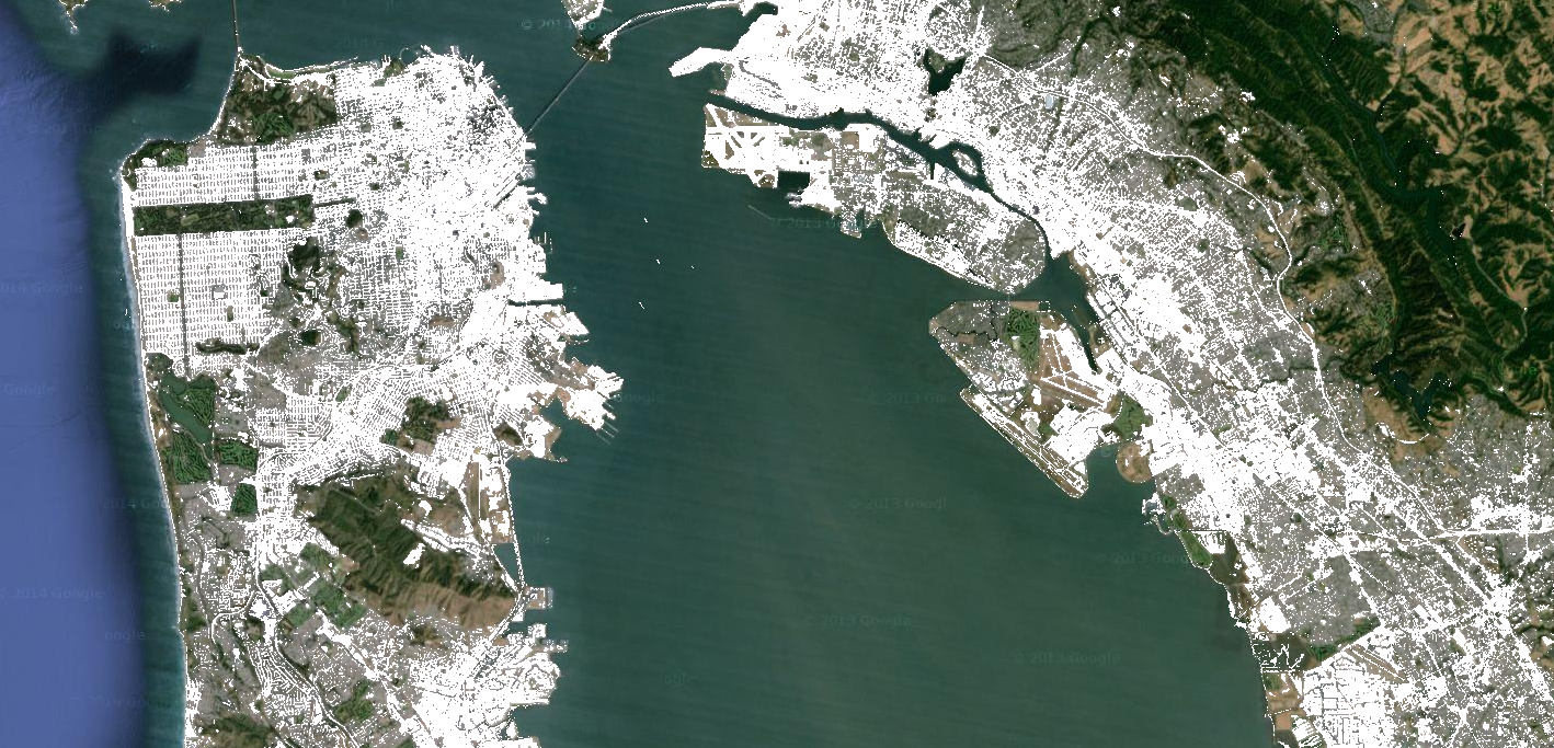 Figure 1. Low NDVI and low NDWI (white) from Landsat 8, San Francisco, California, USA.
The binary images that are returned by relational and boolean operators can be used with mathematical operators. This example creates zones of urbanization in a nighttime lights image using relational operators and image.add():
# Import earthengine API
import ee
from IPython.display import Image

# Initialise
ee.Initialize()

# Load a 2012 nightlights image.
nl2012 = ee.Image('NOAA/DMSP-OLS/NIGHTTIME_LIGHTS/F182012')
lights = nl2012.select('stable_lights')

# Define arbitrary thresholds on the 6-bit stable lights band.
zones = lights.gt(30).add(lights.gt(55)).add(lights.gt(62))

# Display the thresholded image as three distinct zones near Paris.
url = ndvi2008.getThumbUrl({'min':0, 'max':3})
print(url)
Image(url=url, embed=True, format='png')
Note that the code in the previous example is equivalent to using a ternary operator implemented by expression():
# Create zones using an expression, display.
 zonesExp = nl2012.expression(
    "(b('stable_lights') > 62) ? 3" +
      ": (b('stable_lights') > 55) ? 2" +
        ": (b('stable_lights') > 30) ? 1" +
          ": 0"
);
Map.addLayer(zonesExp,
             {min: 0, max: 3, palette: palette},
             'development zones (ternary)')
Observe that in the previous expression example, the band of interest is referenced using the b() function, rather than a dictionary of iable names. (Learn more about image expressions on this page. Using either mathematical operators or an expression, the output is the same and should look something like Figure 2.
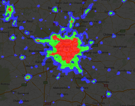
Figure 2. Arbitrary zones of 2012 nightlights imagery for Paris, France.
Another way to implement conditional operations on images is with the image.where() operator. Consider the need to replace masked pixels with some other data. In the following example, cloudy pixels are replaced by pixels from a cloud-free image using where():
# Import earthengine API
import ee
import ee.mapclient

# Initialise
ee.Initialize()

# Load a cloudy Landsat 8 image.
 image = ee.Image('LANDSAT/LC08/C01/T1_TOA/LC08_044034_20130603')
Map.addLayer(image,
             {bands: ['B5', 'B4', 'B3'], min: 0, max: 0.5},
             'original image')

# Load another image to replace the cloudy pixels.
 replacement = ee.Image('LANDSAT/LC08/C01/T1_TOA/LC08_044034_20130416')

# Compute a cloud score band.
 cloud = ee.Algorithms.Landsat.simpleCloudScore(image).select('cloud')

# Set cloudy pixels to the other image.
 replaced = image.where(cloud.gt(10), replacement)

# Display the result.
Map.centerObject(image, 9)
Map.addLayer(replaced,
             {bands: ['B5', 'B4', 'B3'], min: 0, max: 0.5},
             'clouds replaced')
In this example, observe the use of the simpleCloudScore() algorithm. This algorithm ranks pixels by cloudiness on a scale of 0-100, with 100 most cloudy. Learn more about simpleCloudScore() on the Landsat Algorithms page.
-
Portions of this page are modifications based on work created and shared by Google and used according to terms described in the Creative Commons 4.0 Attribution License. Code samples are licensed under the Apache 2.0 License ↩
-
Last updated August 4, 2019. ↩