ARD analysis in Python & Google Earth Engine

The Planet Story
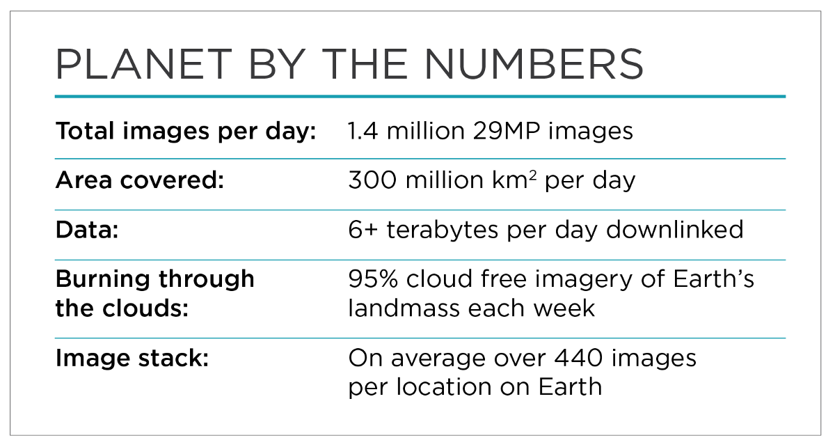
With mission one completed Planet has the capability of mapping the entire planet every single day. We are trying to ask the harder question, the ones that are yet to be asked and answered.

While getting imagery became critically important , the delivery method lead to questions about platforms for analysis. Mission one further meant that you would be able to analyze time series datasets over weekly and bi weekly periods and understand questions that require dynamic analysis such as vegetation patterns, climate variability and changes in hydrological cycles. It generated the single largest trove of high frequency dataset in existence with an unprecedented cadence. You can read more about efforts to create Analysis Ready Data or have at it with the defintion by Chris Holmes and offcourse dive into efforts with the Spatio Temporal Asset Catalog(STAC)
Python and Jupyter Notebooks for Remote Sensing
All good data needs to be analyzed using tools and while there can be many ways of doing that the two primary ways of thinking about is bringing data to the algorithms and sending algorithm to the data. In our current setup we look at both with apporaches. Within the python environment we bring the data home, download it and setup programs to tease out as much as we can from them. The benefit of this method is probably that both the source and end result resides on your machine and you can be offline once you have the data and are just looking at analysis. Using a jupyter notebook apporach gives the user enough in terms of creating a repetable workflow ready to be shared with other users. The challenge comes when you want to scale this to a thousand or more images and running complex functions which requires more power.

Google Earth Engine for browser Based Remote Sensing
With the need to handle such global-scale and often massive data sets, Google was already building and hosting a platform called Google Earth Engine(GEE) designed to analyze geo-spatial data. Google Earth Engine is a cloud based analysis platform that allows for an indexable and queriable raster and vector environment while including and expanding on raster capabilities. It allows for users to perform large scale analysis on large scale datasets such as Planet's very own. You can read more about the Google Earth Engine platform here. I like to tell people that Google Earth Engine does browser based remote sensing , because all you need is an active internet connection and a browser to run this. To bring us to a fair playing field when it comes to analyzing and repeating data analysis.